Charts - Wind charts
Introduction
The Wind charts submodule consists of two charts:
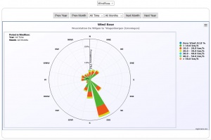
- Wind Rose - Plotting the wind direction and speed in a polar chart;
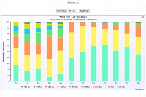
- Monthly Rain - Plotting the wind speed in a stacked column chart;
Below you will find an example image of each chart and an explanation of the origin of the numbers.
Wind Rose
The rather complex chart presents the wind speed and direction in a so called polar chart. For each direction in the compass rose a stacked column is displayed as a cone towards the centre (or from the centre outward). The display is subdivided for every year and every month within the year.
The chart is configured with the following parameters (explained in the chapter Charts):
  WindRoseNrOfWindforceClasses=6                           (default = 6)
  WindRoseMaxWindSpeed=60                                  (default = 60)
Calculation of the Wind Rose
The wind rose is based on the figures in the monthly log files. Those files are read and every measurement has a Latest Wind Speed (See terminology, field nr 14).
The direction is taken from the Current Windbearing, field nr 25. However, field nr 25 does exist only from version 1.9.2 and up. If the datafile is from an earlier version the next best value is taken for the wind direction namely the average windbearing, field nr 8.
Every record in the database is taken as a sample and counted for the speed and direction classes and as such presented in the chart. Especially for the high frequency sampling (one or five minutes) this will give an accurate picture of the wind speed and direction figures. For the lower frequency sampling this picture may be less accurate for the month level.

